by Steve
We've been traveling in Utah in March and early April. Utah has five big national parks, and we've visited three of them. We had previously been to Zion and Bryce, both of which we wrote about earlier. But we've never been to Capitol Reef, the third park that we visited in Utah this spring.
We've been traveling in Utah in March and early April. Utah has five big national parks, and we've visited three of them. We had previously been to Zion and Bryce, both of which we wrote about earlier. But we've never been to Capitol Reef, the third park that we visited in Utah this spring.
We didn't know much about Capitol Reef before visiting it for a week. We knew that it was one of the least-visited parks in Utah, which would be a nice break after the crowds at Zion. We also knew that it wasn't so high in elevation that we've have to worry about cold weather and possibly snow in late March. But other than that we were fairly clueless. I did wonder if "Reef" referred to the fact that much of Utah was covered by a huge sea millions of years ago, and you can find fossils of sea creatures in places that are now quite dry and at 8,000 feet elevation. But that's not what "Reef" is about.
The "Capitol" part of the name refers to a rock formation that looks a lot like the US Capitol dome in Washington DC. "Reef" refers to a large rock ridge rock that forms an almost impenetrable barrier to travel. In Capitol Reef, that ridge extends for over 100 miles north and south, and it prevented settlers heading west from traveling through the area. As a result, this was the last area of the lower 48 states was the last to be surveyed. It wasn't even charted by explorers until 1872.
Eventually, however, a group of Mormon settlers found a way here as they settled much of Utah. They settled in a flat area in a river valley where they could plant and grow fruit trees and other crops. They named their community Fruita, and the orchards still stand today. Now they are part of Capitol Reef National Park, and visitors are allowed to pick fruit when it's ripe. Nothing ripens in March, so we skipped that.
The park has a bit of everything, including arches, narrow slot canyons, waterfalls and pools, petroglyphs, and settlers' trails. While much of the park is accessible only by high-clearance four-wheel-drive vehicles. there still is a lot you can see and do with just a passenger car. We did a number of hikes to interesting features in the park.
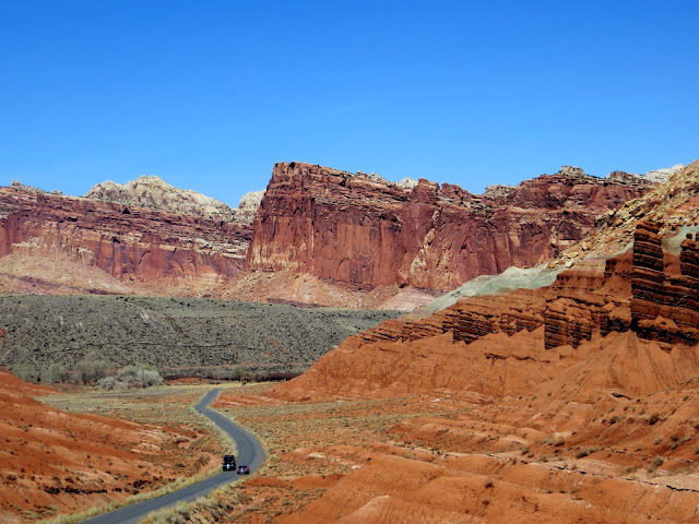
Since the reef was formed by geologic uplift of sandstone layers, which then were eroded forming narrow slot canyons, many of the hiking trails go along the edge of fairly significant drop-offs of several hundred feet. This can induce rather queasy feelings in some people, like Jane. Most of the trails, however, looked worse from a distance than they actually were, including the one we are on in the picture above. Note the car on the road below for scale.
Jane even had the courage to walk out onto Cassidy Arch--so named because Butch Cassidy is said to have had a hideout nearby. That's Jane standing in the middle facing us. (The kids sitting on the arch were all looking at YouTube on their phones. Seriously!)
Once discovered, the narrow slot canyons that traverse the reef from east to west allowed for settlers to travel through the area in the early 1900s. Of course after every flash flood, the road had to be cleared of debris. These early pioneers left their names and dates when they came through by writing them on the walls. These are all still visible today. Current visitors, however, are discouraged from doing the same.
Ancient peoples also left their mark on the place in the form of petroglyphs. There are a variety of human and animal shapes that are still clear, thousands of years later. But their purpose and meaning are largely unknown.
Capitol Reef sits at the northern end of Highway 12, a scenic road that runs from Capitol Reef through Escalante and on to Bryce Canyon. This road runs through some of the most rugged terrain in the country, sometimes with steep drop-offs on both sides of the road. It's a great road to drive, just do it in a car, not an RV. Here's a view from Highway 12.
Highway 12 connects a few small, remote communities. Until the road was completed in 1985, the area was pretty isolated, with dirt roads that were usable only during nice weather. There still isn't too much on the road, so be sure you're fully gassed up before taking the drive. And if you can, stop for lunch at Magnolias in the town of Boulder, Utah, and be sure to chat with the young couple who are owners/chef/wait staff/everything else.
More information on Highway 12 can be found here.
We enjoyed our time at Capitol Reef a lot. March/April is a good time to visit, as the weather isn't too hot yet. As with many of the places we've been, we were able to do and see a lot, but not everything, so we may need to return some day.


