Arches and Canyons
October 09, 2018
by Steve
In October, we had a week in Moab, Utah, and then four days in Blanding, Utah, about 70 miles south of Moab. These towns make good base locations to see Arches, Canyonlands, Natural Bridges, and Bears Ears. Somewhat surprisingly, we had five days of rain, despite assurances from the locals that "it never rains here."
We had been to Arches National Park once before, when our children were little and we were on a family vacation. It was summer, and it was hot. Really hot. We didn't see much of Arches then, as we limited our time in the 100+ degree temperatures. So Jane and I decided on a return trip this fall. And this time we could include Canyonlands National Park.
The photo above is of Delicate Arch, one of the iconic arches in the park and the symbol on the Utah license plates. We hiked here on a nice sunny morning, and while there were a fair number of people here, we did manage to get a few pictures without too much of humanity in them. This is a "must visit" if you go to Arches.
Some of the more interesting arches are a ways off the road and take a bit of a hike. This is nice because it thins out the crowd. The hikes are much more manageable in October than in the heat of summer.
Above is Delicate Arch, one of the longest of the formations in the park. It's about a mile down the trail. The last time we hiked this trail, we caught up with a 96-year-old man hiking in the early morning. After chatting him up a bit, Jane asked him the secret of his longevity. "Don't stop moving" was his reply. Good advice.
Further down the trail is a trio of arches: Portal, Navajo, and Double O. The trail involves travel along the top of one of the "ribs" of rock. This gave Jane an opportunity to work on her fear of heights, sharp drop-offs, and long falls.
Here's Double-O arch. The people in the picture just came though the lower arch and give the picture some scale.
Navajo Arch is much smaller, almost like a tunnel, and straddles a small puddle, the result of recent rains.
Arches is a fairly small national park, and with planning and good weather you can see most of the sights in a few days. By contrast, Canyonlands is a vast park, with much of it accessible only by 4-wheel-drive vehicles or by backpacking. There are three districts, each with its own entrance, and you can't go from one district to another within the park. Plan for some lengthy drives.
The most visited district is "Island in the Sky". It's basically a mesa with lots of overlooks down into deeply eroded canyons. You can visit all the lookouts and do a few short hikes in a day. We had a rainy day with some thunder and lightning, which kept us from any hikes where we would be exposed.
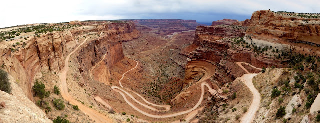
If you have a Jeep and the stomach for it, you can take this road down from the mesa to the plateau below, which overlooks the Colorado River. This Jeep road is a pretty popular trip to take from Moab. If you want to tour the entire road, expect to be out for two days. We stayed on up on the mesa and dodged rain.
We also visited the Needles District. It's an area of rock formations and lots of hiking trails. Not many places that you can go with a car, so plan to park it and get out the backpacks.
Here's a distant view of the Needles. Read the trail signs and carry a map, because it all looks similar and confusing. it has some really interesting terrain.
These formations are called mushrooms, and you can see why.
Some of the trails are a little narrow.
But they lead to great views.
We had a day in the Needles. There's more to see than we were able to do, but we felt that we had a good experience there.
The third district is called "The Maze" and it's accessible only by four-wheel drive. We'll save that for some future trip.
The third district is called "The Maze" and it's accessible only by four-wheel drive. We'll save that for some future trip.
In our next installment, we'll cover highlights of our time in Natural Bridges and Bears Ears, two national monuments in southeast Utah.


0 comments